
The best hikes in San Francisco are short, steep and full of views: Lands End along the coast, Batteries to Bluffs in the Presidio, Mount Davidson, Bernal Heights, Twin Peaks and Glen Canyon. Most take an hour or two, start near a Muni stop and don’t need a car. If you want a full day, the 17-mile Crosstown Trail links many of the city’s green spaces from the southeast corner to Lands End.
In this guide
- At a glance
- Lands End Trail
- Batteries to Bluffs
- Mount Davidson
- Bernal Heights Park
- Twin Peaks
- Glen Canyon Park
- Mount Sutro Open Space Reserve
- Presidio trails
- McLaren Park
- Fort Funston
- The Crosstown Trail
- Stairway walks
- Which hike should you pick?
- Tips for hiking in San Francisco
- Hikes just outside the city
- Frequently asked questions
This guide is part of our outdoor activities in San Francisco hub. Trail conditions change, so check for closures before you go, especially after winter storms.
At a glance
| Hike | Area | Distance (approximate) | Difficulty | Best for |
|---|---|---|---|---|
| Lands End Trail | Outer Richmond | About 3.5 miles round trip | Easy to moderate | Golden Gate views, shipwrecks, Sutro Baths |
| Batteries to Bluffs | Presidio | 0.7 miles one way, with stairs | Moderate | Wild coastline and hidden beaches |
| Mount Davidson | Southwest hills | About 1 mile loop | Easy to moderate | The city’s highest point |
| Bernal Heights Park | Bernal Heights | About 1 mile loop | Easy | 360-degree city views |
| Twin Peaks | Center of the city | Short climbs from parking | Easy | Classic skyline view |
| Glen Canyon Park | Glen Park | About 2 miles of trails | Easy to moderate | A wild canyon in the city |
| Mount Sutro | Inner Sunset | About 2 to 3 miles of trails | Easy to moderate | Shady eucalyptus forest |
| Presidio trails | Presidio | Many loops | Easy to moderate | Variety and forest walks |
| Crosstown Trail | Citywide | Just over 17 miles | Long | A full-day adventure |
Lands End Trail
The Lands End Trail is the city’s most famous hike, and for good reason. It follows the cliffs at the northwest corner of San Francisco, with views of the Golden Gate Bridge, the Marin Headlands and the open Pacific. Along the way, you’ll pass the ruins of the Sutro Baths, the Mile Rock overlook and a stone labyrinth on a point above the water, and at low tide you can sometimes spot old shipwreck remains below.
Start at the Lands End Lookout visitor center near the Merrie Way parking lot, or begin at the Legion of Honor end. The main trail is wide and mostly easy, with some stairs. Side trails down to Mile Rock Beach and the labyrinth are steep. See our Lands End trail guide and Sutro Baths guide for details.
Batteries to Bluffs
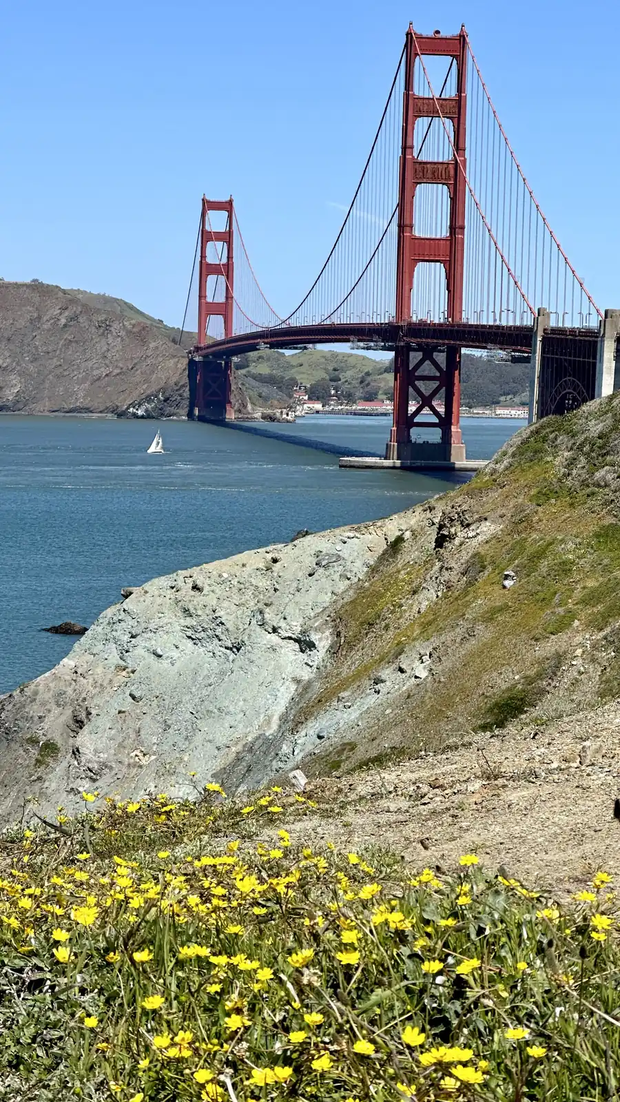
Batteries to Bluffs is a short trail in the Presidio, 0.7 miles one way, with about 470 stairs, according to the Presidio Trust. It runs along the bluffs on the Presidio’s western edge, between old coastal gun batteries and steep cliffs above the Pacific, with views of the Golden Gate Bridge and the Marin Headlands.
Spur trails lead down to Marshall’s Beach, which has one of the best ground-level views of the bridge, and to the rocky shoreline below. The climb back up is the hard part. Wear real shoes, and stay on the trail. The cliffs are unstable. Combine it with a walk along the Coastal Trail to Baker Beach or the bridge.
Mount Davidson
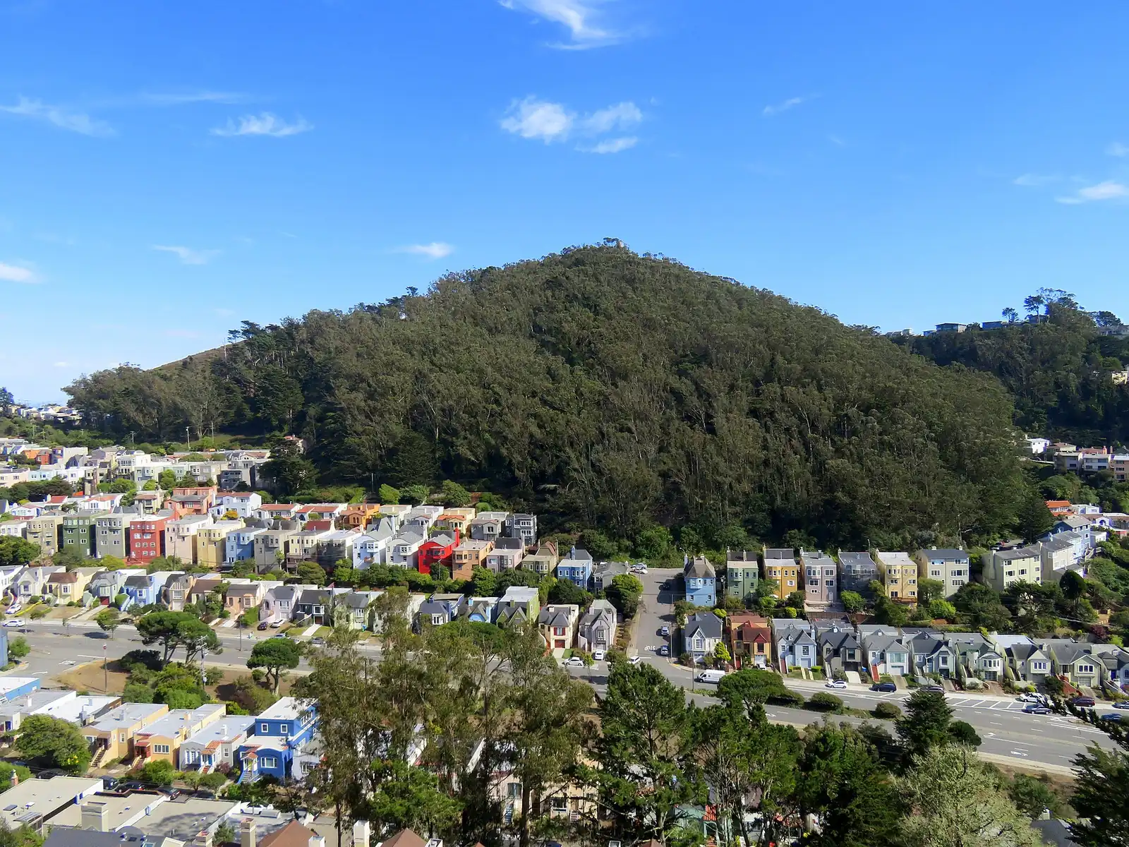
Mount Davidson is the highest point in San Francisco, at 928 feet, but it feels like a secret. It’s a forested hill in the southwest part of the city, with trails winding up through eucalyptus and Monterey pines to a clearing at the top, where a huge concrete cross stands. On a clear day, you can see downtown, the bay and the ocean through gaps in the trees. On a foggy day, it’s quiet and moody.
The loop from the entrance on Myra Way is about a mile and climbs steadily. The 36 Teresita bus stops nearby. Trails can be muddy after rain.
Bernal Heights Park
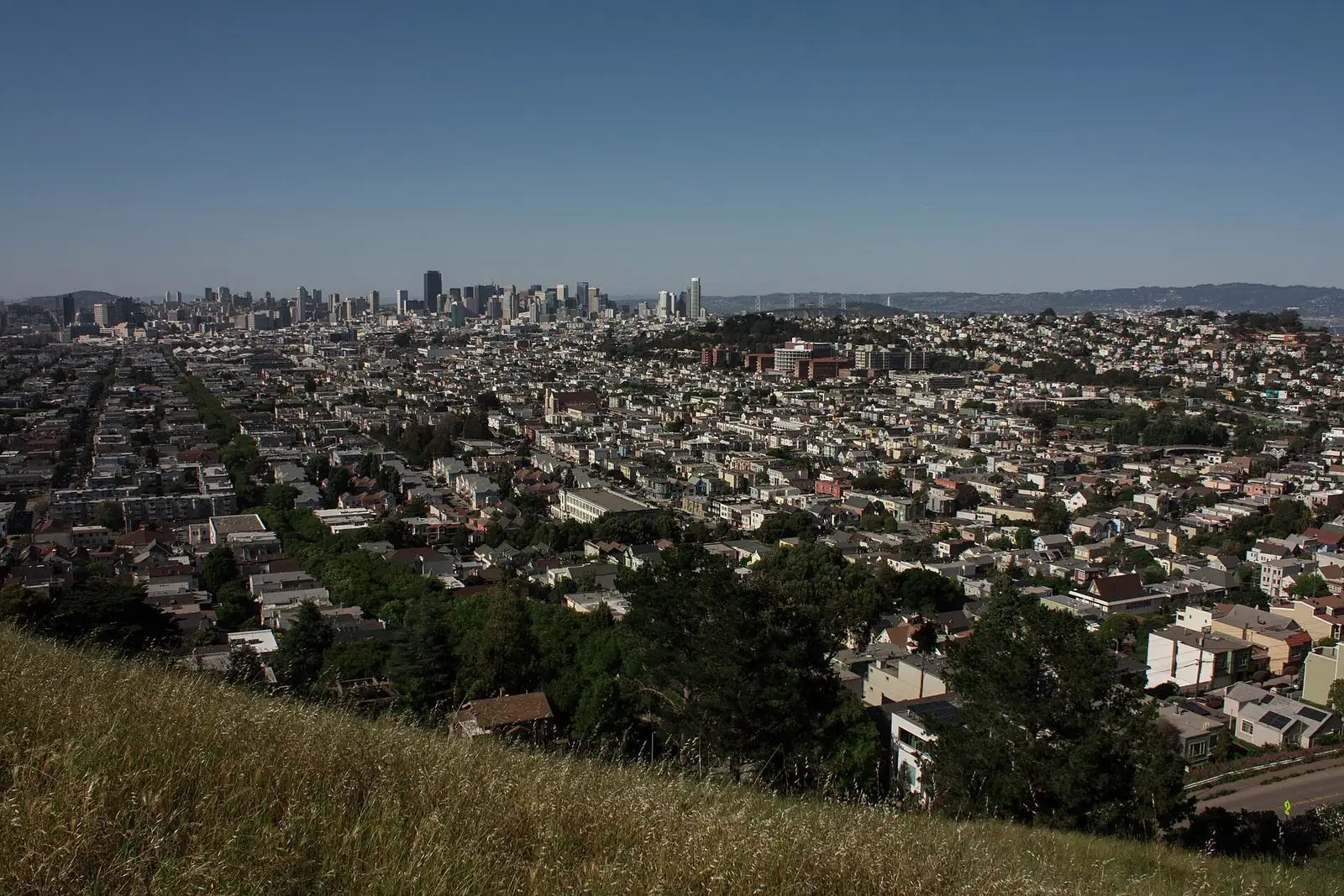
Bernal Heights Park sits on top of a grassy hill south of the Mission, and the loop around the summit has some of the best 360-degree views in the city: downtown, the Bay Bridge, Twin Peaks, Sutro Tower and the East Bay hills. It’s a local favorite at sunset, and it’s very popular with dog walkers.
The paved loop around the top is about a mile, with dirt paths up to the summit rocks. Start from the top of Folsom Street or Bernal Heights Boulevard. Afterward, walk down to Cortland Avenue for coffee or dinner. It’s windy up top, so bring a layer.
Twin Peaks
Twin Peaks is less a hike than a short climb, but the view is the classic San Francisco panorama, looking straight down Market Street to downtown and the bay. You can drive to the parking lot near the top, then walk up either peak in a few minutes. For more of a hike, walk up from Corona Heights or from the Castro, or follow the Crosstown Trail section here. Our Twin Peaks guide has directions.
Glen Canyon Park
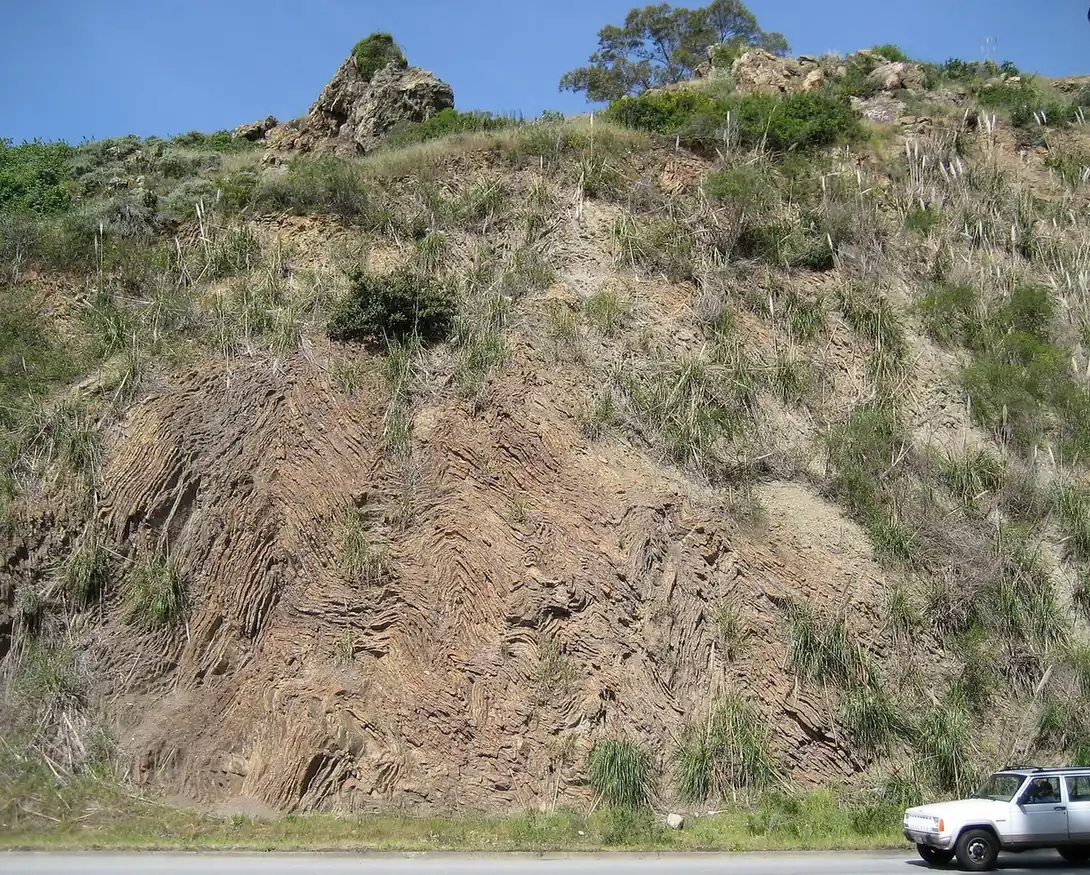
Glen Canyon Park, in the Glen Park neighborhood, feels like a slice of the wild in the middle of the city. Islais Creek runs through the bottom of the canyon, and trails climb past rocky outcrops of red chert, coastal scrub and willows. Rock climbers sometimes practice on the outcrops.
Trails start near the Glen Canyon Recreation Center and from Elk Street. A walk through the canyon and up to the ridges takes about an hour. Glen Park BART is a short walk away, and the village has cafes for after.
Mount Sutro Open Space Reserve
Mount Sutro, above UCSF’s Parnassus campus in the Inner Sunset, is a dense eucalyptus forest with a network of trails, often wrapped in fog. It feels like a mountain forest far from any city. Trailheads start near the UCSF campus and on Clarendon Avenue. Pair it with a walk to the Inner Sunset’s restaurants or the nearby Golden Gate Park.
Presidio trails
The Presidio has miles of trails, including stretches of the Bay Area Ridge Trail and the California Coastal Trail. Good choices include the Ecology Trail through the forest, Lovers’ Lane, one of the oldest paths in the Presidio, and the trails around Mountain Lake. Many trails connect, so you can make a loop of any length. Check the Presidio’s trail maps before you go.
McLaren Park
John McLaren Park, in the southeast part of the city, is San Francisco’s second-largest park after Golden Gate Park, and most visitors never see it. It has grassy ridges, groves of trees, a small lake and a network of trails with views of the bay and the San Bruno Mountains. The Philosopher’s Way, a walking loop with stone markers along the route, is a good introduction. The park also has the Jerry Garcia Amphitheater, named for the Grateful Dead guitarist, who grew up nearby. Several Muni bus lines stop around the park’s edges.
Fort Funston
Fort Funston, at the city’s southwest corner above the Pacific, is part of the Golden Gate National Recreation Area. Sandy trails run along high bluffs, and on windy days you can watch hang gliders launch off the cliffs. It’s one of the most dog-friendly spots in the city, so expect plenty of happy dogs. A steep sandy trail leads down to the beach. Stay well back from the cliff edges, which erode and collapse. It’s about a 10-minute drive south from the San Francisco Zoo area.
The Crosstown Trail
The Crosstown Trail is a 17-mile route that crosses San Francisco from Candlestick Point in the southeast to Lands End in the northwest, linking parks, open spaces, stairways and neighborhood streets. It was put together by volunteers and passes through places like McLaren Park, Glen Canyon, Mount Davidson and Golden Gate Park.
Few people walk it all in one day, though some do. Most hike it in sections, using Muni to get to and from each segment. The Crosstown Trail site has maps and directions.
Stairway walks
San Francisco’s hills are covered with public stairways, and some of them make great short hikes. The Filbert Steps and Greenwich Steps climb Telegraph Hill to Coit Tower through hidden gardens. The 16th Avenue Tiled Steps in the Inner Sunset are a colorful mosaic stairway. The Lyon Street Steps in Pacific Heights have views over the Palace of Fine Arts. See our Coit Tower guide for the Telegraph Hill climb.
Which hike should you pick?
If it’s your first visit, do Lands End. For sunset, go to Bernal Heights or Twin Peaks. On a foggy day, choose Mount Sutro or Mount Davidson, where the mist in the trees is part of the charm. With kids, try Glen Canyon, where the creek and rocks keep them busy. For a workout, Batteries to Bluffs and its 470 stairs will do it. With a dog, head to Fort Funston or Bernal Heights.
Tips for hiking in San Francisco
Dress in layers
The weather changes fast, especially near the coast. A sunny morning in the Mission can be a foggy, windy afternoon at Lands End. Bring a light jacket on every hike. Our San Francisco fog guide explains why.
Watch the cliffs
Coastal trails at Lands End and in the Presidio run close to crumbling cliffs. Stay on marked trails and behind fences. People are injured every year going off trail.
Mind the water
Ocean beaches below the trails have cold water, big waves and strong currents. Don’t swim, and watch for sneaker waves when you’re on the sand.
Use transit
Most trailheads are near Muni stops, and parking at popular spots like Lands End and Twin Peaks fills on weekends. If you drive, leave nothing in your car. Our Muni guide can help you plan.
Bring water
Most city hikes don’t have water fountains on the trail. Bring a bottle, especially on warm fall days.
Hikes just outside the city
If you want bigger trails, some of the Bay Area’s best hikes are less than an hour away. Muir Woods has redwood loops, and Mount Tamalpais has trails with views of the whole Bay Area. See our Muir Woods guide for parking and reservations. The Marin Headlands, just across the Golden Gate Bridge, have coastal trails with views back toward the city.
Planning more hiking in California? Our sister site Trip Musing covers trails across the state.
Frequently asked questions
What is the best hike in San Francisco?
Lands End is the most popular, with coastal views of the Golden Gate Bridge and the Sutro Baths ruins. Batteries to Bluffs in the Presidio is a close second for wild scenery.
What is the highest point in San Francisco?
Mount Davidson, at 928 feet, is the highest point in the city. A short trail loop climbs to the top through a eucalyptus forest.
Are there easy hikes in San Francisco?
Yes. Bernal Heights Park, Twin Peaks and the main Lands End Trail are all easy and short, with big views.
Can you hike across San Francisco?
Yes. The Crosstown Trail runs just over 17 miles from Candlestick Point to Lands End, linking parks and open spaces across the city.
Do you need a car to hike in San Francisco?
No. Most trailheads are near Muni lines, and some, like Glen Canyon, are close to BART.
Photo credits
Featured image: Jeremyone / Wikimedia Commons, CC BY-SA 4.0; The Batteries to Bluffs Trail in the Presidio: lamblukas from San Francisco, United States / Wikimedia Commons, CC BY 2.0; Mount Davidson, the city's highest point: Pi.1415926535 / Wikimedia Commons, CC BY-SA 4.0; Chert outcrops in Glen Canyon Park: Eric A. Schiff / Wikimedia Commons, CC BY-SA 2.5.