
Twin Peaks are two grassy hills near the geographic center of San Francisco, rising about 920 feet above the city. From the main viewpoint at Christmas Tree Point you see almost everything at once: downtown and Market Street stretching to the Bay Bridge, the Golden Gate Bridge, the East Bay hills and, on clear days, the Pacific. It is the classic place to understand the shape of the city.
Quick answer
Twin Peaks is one of the best free viewpoints in San Francisco, with a near 360-degree view over downtown, the Bay Bridge and, on clear days, the Golden Gate Bridge. Go on a clear morning or at sunset, bring a warm jacket for the wind, and expect fog to hide the view on many summer afternoons. Take Muni’s 37 Corbett or a rideshare, and never leave valuables in a parked car.
In this guide
This guide is part of our best views in San Francisco list and our outdoor activities hub.
The view

The Christmas Tree Point parking area faces east, with Market Street running in a straight line from below you to the Ferry Building and the Bay Bridge. To the north you can see the Golden Gate Bridge’s towers and the Marin Headlands. Climb the short, steep trails to the top of either peak for a full 360-degree view, including the Sunset District and the ocean.
When to go
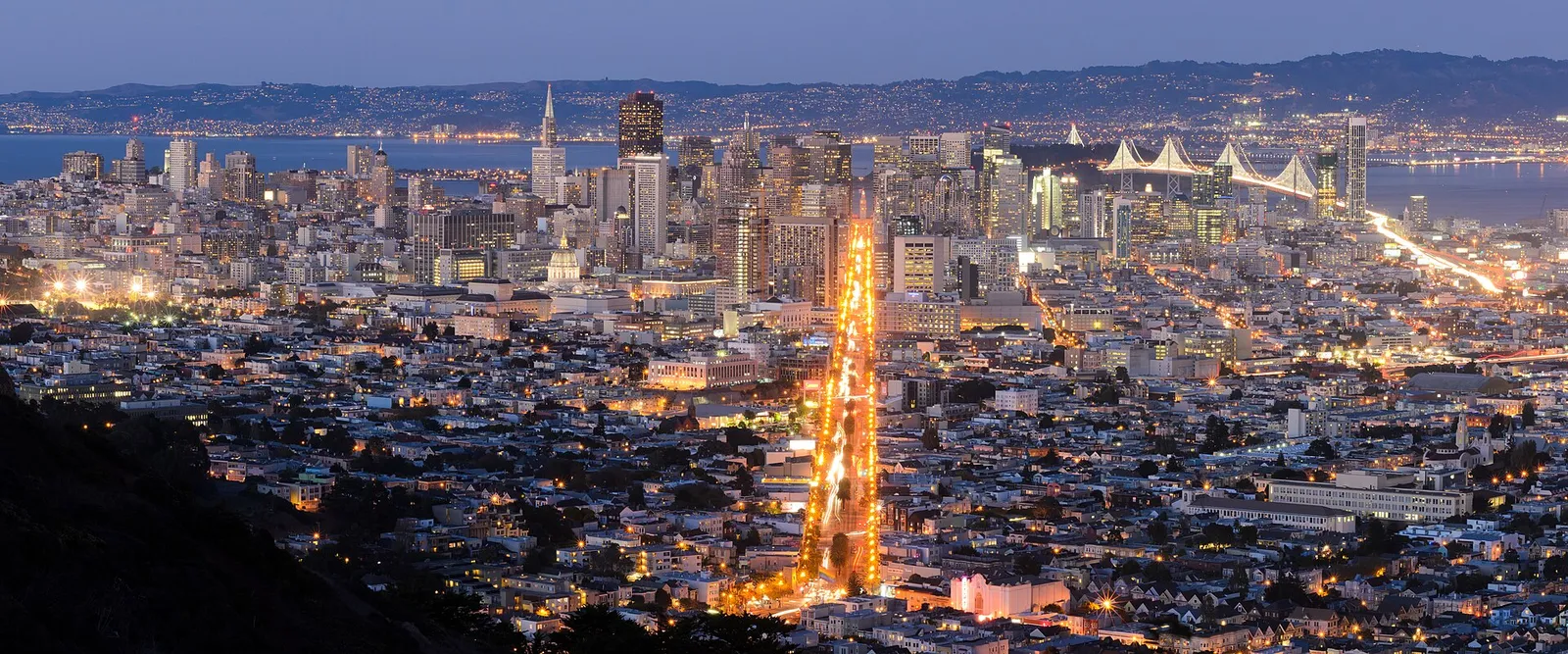
Fog is the big variable. Summer afternoons are often foggy and very windy, while mornings and evenings in fall are usually clearest. Sunset and the hour after, when the city lights come on, are the most beautiful times. Check a webcam or look at the sky from downtown before heading up. Bring a warm jacket in every season.
Getting there
- By car or rideshare: Twin Peaks Boulevard winds up from Portola Drive or Clarendon Avenue to the viewpoint parking lot. Do not leave anything visible in a parked car.
- By Muni: take the 37 Corbett bus, then walk up the trail and stairs from the Crestline area. It is a steep but short climb.
- On foot: hike up from the Castro or Cole Valley via the Twin Peaks trails, a rewarding but steep walk.
- By bike: part of Twin Peaks Boulevard is closed to cars and open to people walking and biking.
Tips
The lot is busy at sunset, so arrive early. There are no services at the top, so bring water. Tour buses stop here mid-morning. For another city view with fewer people, try Bernal Heights Park or Corona Heights. See our best views guide for more.
Official resources: San Francisco Recreation and Parks.
The two peaks and Christmas Tree Point
Twin Peaks has two summits, called Eureka (the north peak) and Noe (the south peak). Most visitors stop at Christmas Tree Point, the parking area and overlook on the northern side, which faces downtown and has the classic view straight down Market Street. Climb the short, steep paths to either summit for a wider view with fewer people.
Just south of the peaks stands Sutro Tower, the giant red-and-white broadcast tower that is visible from almost everywhere in the city. It is not open to the public, but it makes a striking backdrop for photos.
Walking up Twin Peaks
You can walk to the top from several neighborhoods. A popular route starts in the Castro and climbs through quiet residential streets and stairways to Twin Peaks Boulevard. It is steep but short, usually 30 to 45 minutes from Castro and Market. Part of the boulevard near the summit has been closed to cars in recent years, which has made it popular with walkers, runners and cyclists; check current access before you go.
Wear good shoes, because the paths to the summits are rocky and can be slippery when wet.
Wildlife and nature
The grassy slopes of Twin Peaks are one of the last remnants of the coastal scrub and grassland that once covered much of San Francisco. They are home to the endangered mission blue butterfly, which depends on native lupine plants. Stay on the trails to protect the habitat, and look for hawks riding the wind above the peaks.
Other viewpoints nearby
If Twin Peaks is fogged in or crowded, try one of these nearby hills:
- Corona Heights, a rocky hill above the Castro with views of downtown and the Bay Bridge
- Tank Hill, a tiny, quiet viewpoint above Cole Valley
- Mount Davidson, the highest point in the city, topped by a large concrete cross and surrounded by forest
- Bernal Heights Park, with a famous swing and views across the Mission
For views of the ocean side of the city, head to Lands End or the Sutro Baths.
Night views
After dark, the city lights spread out below Twin Peaks, with the Bay Bridge lit up in the distance. It is a romantic spot, but it is cold, windy and dark at night, so bring a warm jacket and a flashlight for the paths. Go with someone, and keep valuables out of sight.
Safety and car break-ins
Twin Peaks has a long history of car break-ins, because tourists often leave luggage and shopping bags in rental cars while they take photos. If you drive, take everything with you or leave nothing in the car at all. Many visitors avoid the problem by taking Muni or a rideshare. Our safety guide and parking guide have more tips.
Photography tips
Morning light from the east lights up the view toward downtown, while sunset puts the sun behind you and turns the skyline gold. On summer afternoons, fog often pours over the hills from the west, which can make dramatic photos if you catch the edge of it. A small zoom lens helps for shots of the Bay Bridge and the Ferry Building clock tower.
Combining Twin Peaks with nearby neighborhoods
Twin Peaks sits in the middle of the city, so it is easy to combine with the Castro, the Haight-Ashbury, Cole Valley or Noe Valley. Many visitors go up in the morning and then walk down to the Castro for lunch.
Frequently asked questions
How high is Twin Peaks?
About 920 feet, among the highest points in San Francisco.
Can you drive to Twin Peaks?
Yes. Twin Peaks Boulevard leads to a parking area at Christmas Tree Point, the main viewpoint.
Is Twin Peaks free?
Yes. There is no charge to visit or park.
What is the best time to visit Twin Peaks?
Sunset and early evening on a clear day, often in the fall.
Can you walk to Twin Peaks?
Yes. A common route starts in the Castro and climbs streets and stairways to the top in about 30 to 45 minutes. It is steep, so wear good shoes.
What is the tall tower near Twin Peaks?
It is Sutro Tower, a broadcast antenna for television and radio stations. It stands just south of the peaks and is not open to the public.
Is Twin Peaks safe?
Twin Peaks is generally safe during the day, but car break-ins are common. Do not leave anything in your car. At night, go with others and stay aware.
Is Twin Peaks worth it if it is foggy?
Not usually. Fog can hide the view completely. If the peaks are fogged in, try again in the morning or try a lower viewpoint on the east side of the city.
Photo credits
Featured image: Christian Mehlführer, User:Chmehl / Wikimedia Commons, CC BY 2.5; When to go: King of Hearts / Wikimedia Commons, CC BY-SA 3.0.